Saturday 31 December 2016

Year End Pageview total = 28,309

Thank you to the readers of this Blog in the year 2016.
Around 6000 Pageviews ,
Looking forward to the New Year and Peace on Earth.
 
Two Toms in the snow.
 
Red morph and grey morph Ruffed Grouse.
 
 
These two guys had five hens to chase through the snow.
 

Monday 21 November 2016

Rules

European Union laws require you to give European Union visitors information about cookies used on your blog. In many cases, these laws also require you to obtain consent.

As a courtesy, we have added a notice on your blog to explain Google's use of certain Blogger and Google cookies, including use of Google Analytics and AdSense cookies.

Dismiss this notification
Your HTTPS settings have changed. All visitors are now able to view your blog over an encrypted connection by visiting https://nipigonmuseumtheblog.blogspot.com. Existing links and bookmarks to your blog will continue to work.
Dismiss this notification

Sunday 6 November 2016

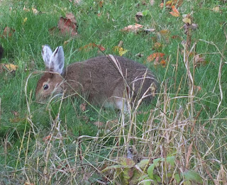
Change is in the Hare

Still only ears and feet turned white so far. Nov. 6
 
Just about a complete change Nov. 6, 2016
 
Keeping a low profile.
Nov. 6, 2016

Tuesday 1 November 2016

October Birding


OCTOBER BIRDING 2016

On October 29 and 30, 2016 Kaarlo’s “group” travelled  through:  the Golf Course Road; Maatta’s Road; the municipality of the Township of Nipigon; Nipigon Marina; the Saw Mill Point Trail; Lake Helen; Polly Lake; Hurkett Dock; the community of Hurkett; Hurkett Cove; and Ouimet Canyon Road.

707 birds divided among 32 species

LIST OF SIGHTINGS


11 Canada Geese

7 Herring Gulls

99 Snow buntings

19 Ravens

80 Rock Doves (Pigeons)

6 European Starlings

36 Hooded Merganzers

6 Crows

53 Black capped Chickadees

6 Ruffed Grouse

16 Common Merganzers

14 Gull species unknown

10 Red breasted Nuthatches

2 Mallards

2 Longtail Ducks

4 Ringbill Gulls

11 Goldeneyes

9 Canada Jays

2 Common Loons

4 Bald Eagles

11 Blue Jays

1 Hairy Woodpecker

2 Juncos

3 Tree Sparrows

7 Trumpeter Swans (Hurkett Dock)

200 Black AND White wing Scoters

1 Pileated Woodpecker

9 Pine Grosbeaks

1 Rough-legged Hawk

65 Terns unknown species

1 Downy Woodpecker

9 Ring neck Ducks

Walleye Conclusion


WALLEYE Conclusion

From: The Status of Walleye in Nipigon Bay Area of Concern: 2012

Prepared for Environment Canada

By: Terry Marshall, Marshall Consulting

March 31, 2013

I am skipping over the next 14 pages of the Report which covers the following topics:

Recent Research, assessment and monitoring studies:

Genetics of stocks

Telemetry studies: seasonal movements and habitat use ( they want to continue this study to see if there really are two distinct spawning populations)

Walleye spawning observations and drift netting Nipigon River

Walleye and Northern Pike abundance: Lake Helen

Fish Community assessment Lake Helen

Electrofishing surveys: Nipigon Bay and River

Fish Community Index Netting: Nipigon Bay

Walleye Population assessment: Nipigon Bay

STATUS OF WALLEYE STOCKS AND THEIR HABITAT IN THE NIPIGON SYSTEM

Reference sites

Recovery of collapsed populations

In all cases, rainbow smelt were also present in these water bodies which is an important consideration  if making comparisons.  The Nipigon Bay East area has the greatest biomass of rainbow smelt documented in Canadian Waters of Lake Superior (Yule et al 2008).  The species was also found to be generally of larger body size in this part of the lake.  The presence of a large and abundant prey such as rainbow smelt has a positive influence on walleye growth energetics.  In Western U.S. reservoirs, growth rate increases once rainbow smelt became a large part of walleye diet [Johnson and Goetti 1999; Groeb et all 2008]. On the other hand, rainbow smelt may also compete with and prey on age-0 walleye which in some instances can significantly reduce their density [Mercedes-Silva et al 2007].


STATUS INDICATORS


Walleye Population status

1.       Abundance remains low – approx. 5000 Lake Helen

2.       Density is increasing

3.       Growth rates are very high

4.       Mortality is very low


Walleye Habitat status


Information needs ;

Genetic analysis of stocks

Population monitoring and assessment


If genetic analysis determines that two discrete populations exist, the size of each must be determined independently.


CONCLUSIONS


There have been many changes in the 50+ years since Ryder’s [1956] early studies and the collapse of the walleye fishery in Nipigon Bay.  There have been drastic shifts in the composition of the aquatic community, along with significant improvements to nearshore habitat within the Bay, and recent changes to the thermal properties of the area brought about by climate warming.  Together , these present a new environment for walleye to which they continue to adapt. This process appears to have promoted the development of two separate stocks of walleye in the Nipigon system.


We have a new  population [or two] of walleye here today, different from the historic population in terms of its genetics, its spawning behaviour, and its annual movement patterns and use of habitat.  This population is thought to be at a relatively low level of abundance compared with historic estimates, but quite healthy in all other respects.  Growth rates are rapid and mortality is low.  Together these traits suggest that large, rapidly maturing fish are present and have the potential to produce quantities of offspring in the future.  Clean, high quality substrate is available in unobstructed spawning areas in both Nipigon and Jackfish rivers and it not constraining recovery.


On the basis of this evidence, it is recommended that the BUI status of the walleye population and their habitat in the Nipigon Bay AOC be updated to “ Not impaired”.


The 40,000 fish target for Walleye recovery may never be achieved in light of all the changes observed in this ecosystem [Colby 2007].  All that can be done to accomplish this has been done.  Maintaining fishing mortality at a low level will help the walleye population expand to achieve its new equilibrium.

Friday 28 October 2016

WALLEYE Rehabilitation Efforts


WALLEYE Rehabilitation Efforts

From The Status of Walleye in Nipigon Bay Area of Concern: 2012

Prepared for Environment Canada

By Terry Marshall, Marshall Consulting

March 313, 2013

In 1991, the historic loss and continued low abundance of walleye in Nipigon Bay was identified as a Beneficial Use Impairment [BUI] in the Nipigon Bay Remedial Action Plan [RAP] Stage 1 document [Cullis et al 1991].  Through the RAP process, multiple actions were identified and implemented in an effort to restore walleye in the Nipigon River including the stocking of adult walleye [Cullis et al 1995]. The Nipigon River walleye stock was later recognized as one of 14 priority areas for walleye rehabilitation around Lake Superior in “ A Rehabilitation Plan for Walleye Populations and Habitats in Lake Superior” [Hoff 2002].

STOCKING


A stocking plan was initiated in 1978 as an approach to rehabilitate the walleye population of Nipigon Bay and continued until 1992 [Wilson 1991]. Initially eggs were stocked, then fingerlings and fry, and finally adult walleye were transferred into the bay.

The source of eggs for the stocking program varied through the years, but included Current River, Onaman Lake, and Lake Nipigon.  Stocking sites included Jackfish River, Condon Island and three sites on the Nipigon River: the Lake Helen access, the highway bridge, and the river mouth.

An adult stocking program began in 1986, with 2,686 fish transferred from Savanne Lake over a four year period.  A further 12,100 fish were obtained from Lac des Mille Lac, Georgia Lake and Lake Nipigon and stocked in the bay from 1990 to 1992 [Wilson et al 2007]. ( and Trapnarrows Lake )


HABITAT RESTORATION

There has been considerable progress in addressing environmental concerns in the Nipigon Bay AOC.  This has included the development of a bioengineered marina at  Red Rock, which features armour stone breakwalls that provide public access and fish and wildlife habitat; the development and implementation of the Nipigon River Water Management Plan, which has provided a workable solution to water use conflicts arising from regulated flows;  and the realignment of Clearwater Creek and Kama Creek, which restored valuable brook trout habitat in the AOC.  The “historic” spawning grounds and the “Old Mill Site” wetland on the lower river were rehabilitated through removal of logs, pilings and debris.  Domtar Packaging Ltd. Upgraded its treatment technology in 1995 to improve the quality of wastewater discharged to Nipigon Bay ( and ceased operation in 2006).  In 2012, the township of Nipigon incorporated secondary treatment to its water pollution control plant.

In 2004, Environment Canada completed an assessment of the sediment contaminants in Nipigon Bay.  The findings suggest that the soil contamination near the vicinity of the pulp and paper mill have reduced to a point that the concentrations are suspected to have no or limited impact on the benthos [Richman 2004].

A recent inventory of benthic macroinvertebrate communities in the Nipigon system suggests a high quality habitat indicative of a highly oxygenated, unimpaired environment [Deacon 2011].

WALLEYE decline - the Sea Lamprey Control Factor

From: The Status of Walleye in Nipigon Bay Area of Concern: 2012

Prepared for Environment Canada

By: Terry Marshall, Marshall Consulting
March 31, 2013


Sea Lamprey Control


An electric barrier on the Jackfish River was operated by the Sea Lamprey Control Center for three years beginning in 1959.  Besides restricting walleye and other fish from moving up the river, it also caused direct mortality with an estimate of 700 walleye killed during its first year of operation alone [R. Ryder pers. Comm., cited in Wilson 1991]
It is unknown how the use of lampricide in later years affected walleye, although there were reports of significant mortality of many different species of fish in the Nipigon and Jackfish rivers following lampricide treatments in the 1960s and 1970s [Wilson 1991]. While early life stages of walleye are thought to be considerably more resistant than sea lamprey ammocoetes to TFM lampricide [Seelye et al 1987]. Recent kills of post spawning adult walleye have been reported following TFM treatment [McChesney 2008; Preddice 2009].

Thursday 27 October 2016

WALLEYE decline - Habitat degradation


WALLEYE – Habitat Degradation factor

From The Status of Walleye in Nipigon Bay Area of Concern: 2012

Prepared for Environment Canada  by Terry Marshall  Marshall Consulting  March 31,2013

Factors related to the Walleye decline in Nipigon Bay


Habitat degradation

In a historical review of Nipigon Bay Walleye, Wilson[1991] detailed the many habitat alterations that affected this population.  The logging industry contributed through damming, deforestation, sedimentation, the accumulation of wood fibre, bark, and other organic matter from historic log drives, and DDT contamination.  The creation of hydroelectric generating stations segmented the Nipigon River isolating fish populations and the altered flow regimes affected stream bank stability, sediment load and the quality of fish and wildlife habitat.  Effluent discharges from municipal sewage treatment plants and a kraft pulp and paper mill were also implicated in the demise of the walleye fishery [Ryder 1968]

WALLEYE: suggested factors for decline


WALLEYE, Factors suggested for Decline

From: The Status of Walleye in Nipigon Bay Area of Concern: 2012

Prepared for: Environment Canada

By: Terry Marshall

March 31, 2013

There has been much debate over what was responsible for the dramatic decline in the walleye population in Nipigon Bay.

A number of factors have been suggested, including overfishing and habitat degradation [Ryder 1968, Wilson et al 2007].  Sea Lamprey control may also have played a role.  Kelso and Cullis [1996] provide a detailed timeline of these various perturbations.

EXPLOITATION


At the time of collapse of the walleye population in Nipigon Bay, less was understood about the dangers of overfishing, with the feeling that fish populations were able to compensate for large reductions in their abundance.  In 1956, in a review of walleye dynamics in the Nipigon River during the peak of commercial harvest, Ryder [1956] reported “… the commercial catch has increased immensely over the past two years, thus reducing the competitive factor among pickerel themselves.  The drastic reduction of Lake Trout … removes a competitive factor making more food available to the pickerel.  It might be concluded then, that the present rate of exploitation is far below the maximum catch that could be taken to improve the quality of  the population… the harvest has not yet approached the point where optimal benefits to the pickerel population and subsequently to the angler are received.”

This proved to be false, as the walleye population rapidly declined over the next few years.

In Nipigon Bay, the commercial harvest was a classic example of fishing a stock down to insignificance.

Within this Bay, walleye were very concentrated post-spawn, and gillnet and poundnet operations targeted them very effectively.  The gillnet catch-per-unit-effort [CUE] remained extremely high through the latter period [1959-63] of reduced abundance, revealing the efficiency of the fishermen as they became more attuned to the fish’s seasonal movements [Ryder 1968]. In addition , a substantial angling fishery also existed [Schram et al 1991]

The walleye catch in Nipigon Bay from all commercial gear during the eight peak years of harvest prior to the collapse [1951-1959, 1956 excluded]  totalled 97,245 kg.  The average weight of walleye in the catch can be assumed to be similar to that reported for the Black Bay harvest , which was 0.87kg [P. Addison, pers. Comm.].  This then translates into an annual harvest of about 14,000 walleye which when related to the estimated population size of 41,000 mature fish [Ryder 1968] implies an annual exploitation rate of 34% [or higher, including the angling harvest].  While this high of an exploitation rate may arguably be sustainable in more southern locales [ Schmalz et al 2011], it has never proven to be the case in the colder waters of Ontario [Baccante and Colby 1996]

Nipigon Bay and the Nipigon River were closed to commercial fishing for walleye in 1984 and to angling in 1989, along with the Jackfish River.

WALLEYE part one


WALLEYE

From the Status of Walleye in Nipigon Bay Area of Concern: 2012

Prepared for: Environment Canada by: Terry Marshall, Marshall Consulting,

 March 31, 2013

Introduction


Nipigon Bay was designated an Area of Concern (AOC) in 1987 under the Canada-United States Great Lakes Water Quality Agreement.

The degradation of fish populations and the loss of fish habitat were beneficial use impairments (BUI) identified in Stage One of the Remedial Action Plan (RAP).

One of the fish populations that had been greatly reduced in numbers is that of Walleye (Sander vitreus).  Overharvesting, degraded habitat, pollution and the construction of dams have been identified as possible factors.

There have been a number of research and assessment studies in recent years supported by the RAP process to learn more about Walleye and their use of existing habitat and to monitor their population recovery.  Ontario Ministry of Natural Resources (OMNR) Nipigon District, OMNR Upper Great Lakes Management Unit, OMNR Aquatic Research and Development Section, Anishinabek/Ontario Fisheries Resource Centre and the Red Rock Indian Band have all contributed to this field work.

A Brief Overview of the Walleye Stocks in Lake Superior


The Walleye populations of Lake Superior have always been relatively small and widely scattered due to limited amounts of available habitat [Schneider and Leach 1977].  Within this lake they are confined to shallow embayments and the estuaries of moderate to large rivers which afford suitable conditions for spawning and the protection of juvenile fish.

Historically, the three largest stocks of walleye were found in Black Bay and Nipigon Bay, Ontario, and in the St. Louis River at Duluth, Minnesota [MacCallum and Selgeby 1987].

Smaller populations occur elsewhere around the lake, where smaller rivers and protected bays provide appropriate habitat.

Exploitation has been an ongoing source of stress to these walleye populations, with commercial harvest records going back to about 1870.  In the early years, most of the harvest came from Michigan and Wisconsin waters, but from about 1920 onward harvest was largely from Ontario, with Black Bay contributing about 90% of the yield until the collapse of its walleye fishery in 1968 [Schneider and Leach 1977; Schram et al 1991]. In Nipigon Bay, an increase in the commercial walleye harvest occurred in the late 1940s as lake trout stocks declined through overexploitation and sea lamprey predation [Lawrie and Rahrer 1972].

Following a number of years of high harvest in the 1950s, the walleye population declined catastrophically with no harvest reported from 1966 onward.  The Whitefish Bay stocks were also fished commercially at the Goulais River and in Batchewana Bay until their decline in the early 1970s [Schram et al 1991].

As a result of these intense fisheries, along with pervasive habitat degradation, walleye fisheries declined across Canada at this time.  Country-wide, the annual catch of walleye fell from 9,090,909 kg in 1955 to about 2,954,500 kg in 1971 [Hartman 2009]

The populations that persisted all lacked a commercial fishery.  This included the smaller Thunder Bay populations near the mouths of the Current, Kaministiquia, Pine and Pigeon rivers.  Schram et al [1991] reported these to have been only lightly fished by anglers with all populations appearing stable, although habitat loss has subsequently been identified as an issue [ Solec 2012].  The St. Louis population was the only large stock of walleye to survive this period and continue to be one of the healthiest stocks in the lake [Solec 2012]. Interestingly, it too was not commercially fished as the walleye had an objectionable flavour attributed to chlorophenolic products released from upstream paper mills [Margenau and Schram 1982; MacCallum and Selgeby 1987].

Sunday 23 October 2016

A new meaning for FOREST SERVICE


A New Meaning for FOREST SERVICE

Previously I have written ( January 2007) that I considered non-market value of forests “ imaginary money – empty pockets at the end of the day.”

There may be light in that forest.

Reading a “Valuation of forest ecosystem goods & services and forest natural capital of the Beijing Municipality, China, by Wu, Hou and Yuan, 2007… They conclude that when a “people/community” have to “forgo some forest uses”  in order to maintain a sustainable flow of forest protection services – these forgone benefits need to be compensated.

Has anyone read anything about compensation for our forest industry communities in Ontario? Canada?

China would impose an environmental tax and water resources fees to be used to “promote sustainable forests” or “compensate local communities.”  ( I don’t like the OR in there)

While Ontario Hydro does put money back into local communities, that is for the Nipigon River Water NOT forest non-market value as water retention in the soil/watershed protection.

This 2007 study is themed “Forests in the Service of People.”

The “framework” Hou and Wu used for their study makes it a lot easier to see where they are coming from.  Computing the “yuan” or “dollar” value as they say,”  calls for a certain degree of subjectivity.”

One value they use comes from the Biomass expansion factors of the IPCC, 2004 which places a tonne of CO2 at $23 U.S.

The “framework” divides into two sections:

Forest Natural Capital Stocks and Annual value flow of forest ecosystem goods and services.

Forest Natural Capital Stocks is divided into : Forest land assets; Standing timber assets; and Forest environmental assets.

The Annual value flow of forest ecosystem goods and services divides into three sub groups: Forest Goods; Forest Environmental Services; and Sociocultural Benefits

Forest Goods represents: Annual increment; products of economic forests; and non-wood forest products.

Forest environmental services splits into nine sections:

 Water Conservation

Soil Protection

Agricultural Protection

Carbon Sequestration and Oxygen Supply

Biodiversity Conservation

Air Purification/ Temperature Regulation

Forest Ecotourism

Job Opportunities

Science and Education

The Sociocultural Benefits are : Aesthetics and Living Conditions; Cultural/Artistic Services; and Spiritual/Historical Services.

All this number crunching is aimed at a “macro-level policy evaluation  within and beyond the Forest Sector.”

And, they figure once you have read this study it will get you started in having some real great debates.

Gold in Red Rock , too

Over the rec centre
 
Seeing Lloyd's Look-out
 
The Red Rock to Nipigon hiking trail goes  over these hills.
 
The Nipigon River Highway Bridge construction of the third tower - crane can be seen.
As seen from Red Rock Marina October 21, 2016.
(Gold being spent)

Friday 21 October 2016

Gold on Earth


Morning Sun creating Gold on Earth
October 20, 2016
 
Morning sun coming between clouds
 
October 20, 2016

Tuesday 18 October 2016

Dueling Ground

Gray Morph Ruffed Grouse and Red Morph Ruffed Grouse
October 18, 2016
 
Contestant Number One
 
Contestant Number Two
 
More action.
 
The Strut.
 
Full Pose.
 
Don't believe he moved an inch.
October 18, 2016
 

Monday 17 October 2016

A Wet Day But Life Goes On

Courting Grey Morph Ruffed Grouse.
October 17, 2016

Feet First

Our varying Hare seems to turn from the ground up and the top down.
October 17, 2016

Wednesday 28 September 2016

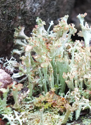
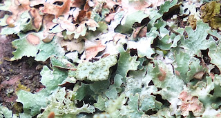
LICHEN WHERE I WALK

Lichen Where I Walk
Lichens of the North Woods by Joe Walewski… a field guide to 111 northern Lichens. Published by Kellath + Stensaas, Duluth MN 2007.  Purchased from Amazon last week and I had to wait for the rain to stop to go looking with my camera. As it was a shower caught me.
Map shows greater density of growth around Superior the farther West you travel from Wawa to about Two Harbors. The Lower shore from Duluth to Agawa is moderate to low.
North America has 3600 species of lichen and our North Woods more than 700 of those.
Isle Royal has over 600 species of lichen so Joe considers it a   “hot spot”.
This field guide sorts the lichens by what they grow on – ground, rock and trees/wood.
I haven't named these lichen. I've got all winter to sort them out.


Sunday 18 September 2016

EASY RIDER

Merlin
 
September 17, 2016
Watching for chipmunks.
 
The reason no birds were singing that morning.
 

Saturday 10 September 2016

Describing the Nipigon River in 1876


NIPIGON BAY, LAKE SUPERIOR  1876

Written for the Thunder Bay Sentinel newspaper by A. Walpole Roland, November 13, 1876

SIR—In consequence of the early closing of Navigation I was unable to forward the promised sketch of the Nipigon Lake and River district before the departure of our first winter mail, which leaves here “weather permitting” on the 14th proximo.  Of the River as a famous trout stream, little remains to be said that is not tolerably well known to most of your readers,  but of the district, generally, it may be said to afford a rare example of the economy of nature in grouping together --- the useful and the beautiful.

Rock and River --- tinged with Amethyst, half seen, half hidden, by the hazy mist.”

Of the native grandeur of the surrounding scenery there can be no question; and that the soil is in many places as rich and good as any in the lower Provinces is fairly admitted by competent and impartial judges;  and of its mineral wealth, etc., more anon.

The River is the largest and clearest water flowing into Lake Superior --- and the Harbour entrance with bald ridges of columnar trap, and red rock, rising from the water edge to a perpendicular height of nearly 500 feet is very picturesque.  At this point the River measures about two thousand yards but gradually opens out on the west side, where the high saddle-back headland runs due west, giving place to a rich belt of splendid land carrying north east to the River’s mouth and forming a perfectly secure Harbour with sufficient depth of water for vessels of any class.  A steamboat channel runs nearly straight and due north to the H.B. Co.’s Post, Red Rock, a distance of three and a half miles from entrance to the Harbour, where navigation by steamer , may be said to end.

Then the Hudson’s Bay Company held an important trading post and Depot for their interior supplies, and one of the finest docks west of Montreal, measuring over 130 yards, with a depth of from 11 to 14 feet of water at all seasons.

 Many improvements have been made in this district, and within the last few years Townships and town lots have been surveyed and disposed of to eager and ENTERPRISING speculators, at a time when hopes were fondly entertained, of this becoming the Lake Superior terminus of the coming railroad.

Nipigon , however, like your own magnificent Thunder Bay, lacked the necessary natural qualifications, that is, an “old sand bar,” consequently the scheme was abandoned and the terminus “moved on” – to a more favoured location.

The Nipigon it is true, can boast of a small “sand bar” of her own, as one or two Lake Superior Captains can testify with regret.  But why did they attempt the impossible feat of making a short portage instead of coming by the old route?  In a previous letter I gave a brief description of the “Co.’s” Post etc., so that excepting  an additional “exploratory line” there is nothing new and really , judging from the number of C.P.R. lines together with the absence of any real engineering difficulty we may yet see this portion of the railroad in progress.  But until the financial difficulties are bridged over, we cannot reasonable hope of, ever hearing of the discovery of a practicable route.

Going Up The River

Near the H.B.Co.’s dock , commences one of the swiftest currents on the River, sweeping downwards from the Lake Helen rapids with a velocity of 5 knots per hour.  Lake Helen, a beautiful sheet of deep, clearly blue water, is nine miles long,  two broad and one mile from steam boat dock.  The River enters this lake from the west side, and its upward course is N.N.W. to camp Alexander, a distance of five miles, where the current is again pretty stiff to the Alexander rapids, when another portage is made by canoeing up Portage Brook for one mile, and where a portage of two miles connects to Lake Jessie.  Opposite Portage Brook is Cameron’s Pool, “Pectorabus Sacrum,” where Mr. Cameron of Cincinnati , and the Isaac Walton of the Nipigon, has for 15 successive seasons, landed speckled trout that would rather astonish the author of the “Complete Angler.” Lake Jessie or Minor Lake is a very pretty bit of water, -- with numerous small islands, and separated from Lake Maria by the Narrows, where the River measures no more than 100 yards across.  The entire distance over both lakes including “ the Narrows,” is about 6 miles, the next portage is “Split Rock”, and is but a short one. The scenery here is very fine and continues to improve as we ascend , the River being here bounded on both banks, by high ridges of black traprock.  A little higher up Island Portage is made ( or run by a small canal) by curving over a small rocky Island in centre of the River.

One miles brings us to the foot of Pine, or “One Mile Portage”. Another mile from the head of Pine Portage is a rather dangerous fall, or rapid, where the water comes flowing down as they do at “Ladore.”  Near this fall is Little Flat Rock Portage, where the H.B.Co.’s  canoe route branches off, running West through Lake Emma and Hanna and reaching Lake Nipigon by an easier and more direct route than that of the River, when rapids increase in number and velocity between Lake Emma, Camps Victoria and Minor, to the Grand Fall, or head waters of the River St. Lawrence.  We now stand on the South Shore of Nipigon Lake, and about 350 feet above the level of the mouth of the River and distant about 33 miles.

This spot may be called the Ultima Thule of tourists and sportsmen all in this direction: few caring to advance beyond the Falls from whence a very fine view of many of the islands is obtained, bounded in the west, by the pale blue mountains, and in the far away north by the sky. This great inland sea measures nearly 70 x 50 miles, with over 1,000 islands of various dimensions;  and a coast line of over 500 miles.  Among the many natural features worthy of special mention an “Echo Rock” and the Inner and Outer Barn, the latter rising from the surface of the Lake almost perpendicularly, to a height of over 600 feet, with tons of over-hanging masses of rock apparently ready to come tumbling down upon the slightest provocation;  while higher yet the hardy fir and mountain ash flourishing luxuriantly and waves defiance to the winds. How truly are these subjects worthy of the magic touch of the artist’s pencil. Never have I witnessed more equitable changes of light and shade, not more striking contrasts of the bold and beautiful.  As I close this hurried sketch the “Indian Summer” sun is fast disappearing behind the lofty Mount St. John with a brilliant glow of fiery red, that brings back pleasant memories of sunsets in Oriental claims:

Is there not in yonder glorious scene,

A beauty and a grandeur not of earth

A glory breaking from yon cloudy screen;

Revealing to the (…) its nobler berth!

The Nipigon region has been thoroughly explored by Captain G. B. Weeks, with his Surveyors and assistant, (under the direction of Professor Campbell of N. York,) with the most satisfactory results.  Captain W. is at present supt. one of his latest discoveries, “The Victoria” and when last heard from had out “150 tons good ore, with 300 of low grade concentrating ---and shaft 30 feet.”

At a more convenient time I shall have much pleasure in giving particulars of current events.  Mining, I am assured, will go ahead here lively, bye and bye.  “Rome wasn’t built in a day,” you know.

-          A. W. R.